APT 1.0
Air Pollution Transmission Software
APT software can be used
- for point sources, surface sources, line sources
- for several polluting sources of different types
- for specifying of the sphere of effect
- for steady and instantaneous emission
- regarding short and long averaging time
- concerning plain soil surface or by taking the relief into account
- within 20 km distance from the sources
The use of APT software
- Preliminary phase: input data setting\
- basemap and -optionally- relief map
- the features of the ground
- source- and emitted gas parameters
- source ID, coordinates, height, diameter
- the output speed and temperature of the exhaust gas
- fuel type
- meteorological parameters
- wind-speed, wind direction, air temperature, stability indicator, precipitation
- meteorological table for long averaging time modelling
- pollutants parameters
- emissions of the sources
- immission limit values, background concentration, size of the dust particles
- Results: output data generating
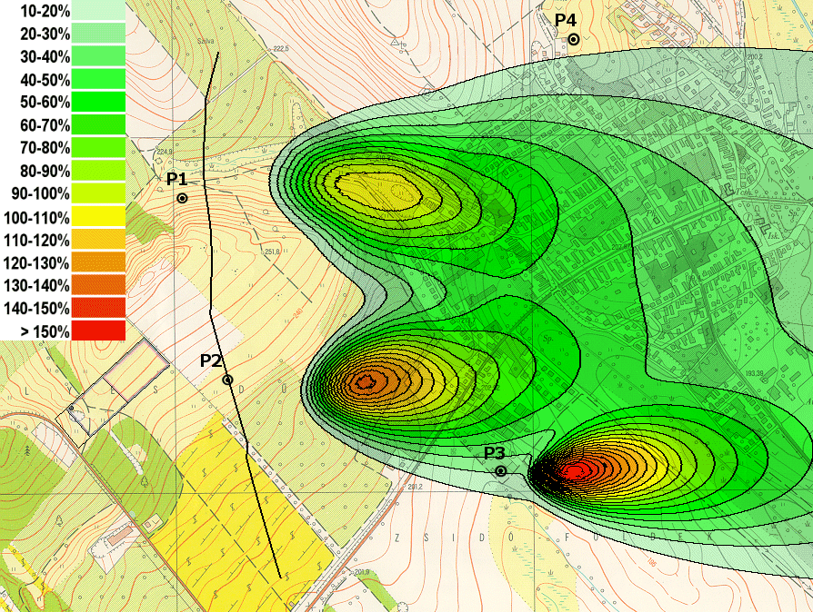
- digital distribution-maps by concentration tail and/or isoconcentration representation
- numerical results in grid points for GIS applications
Environment
Basic publications
-
Mészáros, Cs., Rapcsák, T. and Sági, Z.: Pollution transmission in the
air, in: Large-Scale Computations in Air Pollution Modelling, Kluwer Academic
Publishers (1999) 235-247. (volume of NATO Advanced Research Workshop)
Some references in Hungary:
For more information, please, contact
János Fülöp, Room L511.
Research Group of Operations Research and Decision Systems
e-mail:
phone: (36-1) 279-6112, fax: (36-1) 209-5267
|